Sustainable communities

City of Easton Ordinance Targets Foreclosures, Abandoned and Blighted Properties

easton city sealThe City of Easton (PA) has enacted an abandoned property ordinance  (pdf) to combat neighborhood deterioration, targeting property foreclosures, and abandoned and blighted properties.  It creates an array of new tools for the City to eliminate nuisance conditions, promote neighborhood stability, and protect property values. The new tools include:

  • creating a registration system for properties that are in default of a mortgage, foreclosed, abandoned or blighted;
  • requiring owner and mortgagee inspections of properties that are in default of a mortgage;
  • requiring owners who do not live within a 30-mile radius of the City to designate a local property manager;
  • imposing an escalating annual registration fee for properties in default of a mortgage, abandoned or blighted;
  • imposing new property maintenance standards in addition to existing city property maintenance codes, including duties on mortgagees;
  • requiring owners and mortgagees to maintain such properties in a secure manner to prevent access by unauthorized persons;
  • creating additional authority for the city to lien properties for costs incurred by the city to assure compliance with maintenance standards;
  • imposing substantial fines (not less than $1,500) for violations, including a failure to: register the property, pay any fees within 30 days after they are due, or maintain or secure such properties.

The new ordinance was prompted by the large number of foreclosures and property vacancies induced by the implosion of the market for securitized mortgages and collateralized debt obligations and the resulting Great Recession.  Following abandonment by owners, foreclosing banks frequently refuse to take responsibility for property maintenance.  The National League of Cities has recognized this as a nationwide problem.  Property owners, property mangers, and mortgagees for properties located within the City of Easton would be well-advised to familiarize themselves with these new requirements.

Pa. Appeals Court Strikes Down Act 13 Natural Gas Drilling Law as Unconstitutional

In a 4-3 decision issued today in Robinson Township, et al. v. Commonwealth of Pennsylvania (284 MD 2012), the Commonwealth Court struck down as unconstitutional Pennsylvania's "Act 13", a law that provided that natural gas well drilling, waste pits and pipelines be allowed in every zoning district, including residential districts.  In its 54-page opinion, the Court stated: Because the changes required by [the law, at 58 Pa. C.S. §3304] do not serve the police power purpose of the local zoning ordinances, relating to consistent and compatible uses in the enumerated districts of a comprehensive zoning plan, any action by the local municipality required by the provisions of Act 13 would violate substantive due process as not in furtherance of its zoning police power. Consequently, the Commonwealth’s preliminary objections to Counts I, II and III are overruled.  

Because 58 Pa. C.S. §3304 requires all oil and gas operations in all zoning districts, including residential districts, as a matter of law, we hold that 58 Pa. C.S. §3304 violates substantive due process because it allows incompatible uses in zoning districts and does not protect the interests of neighboring property owners from harm, alters the character of the neighborhood, and makes irrational classifications. Accordingly we grant Petitioners’ Motion for Summary Relief, declare 58 Pa C.S. §3304 unconstitutional and null and void, and permanently enjoin the Commonwealth from enforcing it.

This decision may have impacts which go beyond natural gas drilling. In particular, other statutory provisions purport to require municipalities to allow timbering in every municipal zoning district. We'll offer some further thoughts on the implications of this decision in a future blog. In the meantime, those interested in reading the opinion can find it on the Pennsylvania Commonwealth Court's website here.

Rising Currents: Re-Visioning New York City Through the Lens of Climate Change

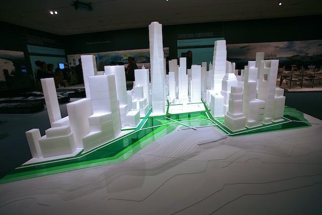
"Rising Currents", a current exhibition at the Museum of Modern Art presents a dazzling synthesis of environmental science, art, architecture and visionary design. The work, by five interdisciplinary teams of design and architectural firms, re-visions the urban landscape of New York City to confront a world altered by rising sea levels and storm surges induced by climate change.

The exhibit space dramatically presents a series of design ideas expressed through display boards, multimedia, physical models, and computerized data visualizations.

The design work is supported by a foundation of detailed scientific analysis, documented in Guy Nordenson's remarkable book, On the Water|Palisade Bay (a product of beautiful design in its own right - kudos to Lizzie Hodges). The teams used the tools of science - fluid dynamic modeling, geographic information systems, quantitative analysis of dynamic systems - to inform environmentally and socially sustainable landscape and infrastructural designs.

The resulting design strategies seek to offer protection to the urbanized spaces of Lower Manhattan and Palisade Bay from rising seas and increased storm intensity and frequency. In some cases, they do so by inviting the water to enter and to accommodate its presence through softened infrastructure and landscapes which "rethink the thresholds of water, land, and city". The design objectives include construction "of an archipelago of islands and reefs along the shallow shoals of the New York–New Jersey Upper Bay to dampen powerful storm currents as well as encourage the development of new estuarial habitats","revitalize the waterfront by designing a broad, porous, 'fingered' coastline which combines tidal marshes, parks, and piers for recreation and community development."

The visualization of these new spaces forces the viewer to re-evaluate the relationship between "natural" forces and human activity which now so dramatically influences them. This is an exhibit for the scientist, the artist, and the concerned citizen in each of us. A detailed exhibition blog provides more information. The exhibit runs through October 11, 2010.

(Exhibition photography © 2010 Armen Elliott Photography, www.armenphotography.com).

Green Maps® Go Mobile: "What's Green Near You?"

GreenMap®,the global award-winning community & environmental mapmaking system, is launching its new mobile platform for smartphones, PDAs and other hand-held devices, making its Open Green Map system available to mobile phone users on-the-go.

The Lehigh Valley's first Green Map - the Environmental Features of the City of Easton, Pennsylvania is now available for mobile users. The Green Map was created through a partnership between Easton's Environmental Advisory Council and Lafayette College's Mapping Urban Ecology course.  Mobile smartphone users can now access the Open Green Map system and by entering their location will see a list of "green" and community sites nearby. Each site references more detailed information and is linked to Google Maps. 

Now in its 15th year, Green Map System has engaged communities worldwide in mapping green living, nature and cultural resources with a unique system of mapping icons and adaptable tools.  The system promotes inclusive participation in sustainable community development with perspective-changing Green Maps that chart local natural, cultural and social resources.

From Green Map: "Open Green Map creates an interactive space for everyone to share their insights, images and impacts about local green sites of all kinds. Open Green Map connects the booming 'go local,' green development and ecotourism movements, empowering widespread participation in critical local environment, climate and equity issues worldwide. Based on open source and familiar mapping technologies like Google Map, Open Green Maps are always available, easily updated, expanded and explored in online, mobile and custom formats, to celebrate sustainability and social resources without barriers."

Among its honors, Green Map System is a recipient of the US National Sustainability Award in New Communications Tools, listed among the 100 United Nations Best Practices, a Technology Benefiting Humanity Laureate, and a Stockholm Challenge finalist.